

In
Blog 2022
Breaking water: the dilemmas of dis:connection in the global-South city
sujit sivasundaram
In this blog, I investigate the work that went into the making of breakwaters in Colombo, Sri Lanka, around 1900 as a way of meditating on the relations between the environment, urban change, labour and politics in a global-South city.[1]Arms stretching to sea
After the opening of the Suez Canal, Colombo became the second-most-used port in British Asia. By 1910, it was slightly behind Hong Kong and the seventh-busiest of the world’s ports by tonnage, easily ahead, for instance, of Calcutta/Kolkata or Bombay/Mumbai. At the heart of this transformation were infrastructural arms stretching out to sea, taming the winds and waves, and allowing steamer ships to dock in calm water for re-coaling. These arms were the breakwaters of Colombo. A south-west breakwater was constructed by 1885, followed by a further bout of infrastructural consolidation in the late 1890s and early 1900s and the building of a north-east and north-west breakwater. More recently, when I returned to Colombo in 2021, after being stuck in Britain over the course of the early pandemic, it was a shock to see another new arm stretching out to sea from Galle Face Green. This is Colombo’s $15 billion dollar Port City Development Project, an attempt to make it compete with megacities such as Singapore and Hong Kong and financed by China.[2] Meanwhile, Galle Face Green, on the seafront, was first formally laid out by the British as a parading and sporting ground in the mid-nineteenth century. One tradition is that the Dutch, who preceded the British, needed this level lawn to aim their cannon at the Portuguese. The new port city development project that faces this lawn has proceeded regardless of protests from environmental groups, fishing communities and from those concerned with the huge debt-burden to China which it will create. It is also at Galle Face Green that the wide-scale protests against the Sri Lankan government, in the midst of a pandemic-inflected economic crisis, arose. ‘Gotagohome village’, calling for President Gotabaya Rajapaksa’s resignation, became a permanent site of protest on Galle Face Green in 2022.[3]Image: Dhammika Heenpella
Staging connections and the reality of disconnection
The breakwaters of the past and the Chinese-financed project of the present are attempts to make Colombo a connected node of global capitalist trade and politics. If so, thinking with the underside of this infrastructure, meaning the work that goes into its making and the way it changes the environment, takes us in turn to the interrupted dynamics of projects like this. It also takes us to why the sea face of Colombo continues to be a place where politics is appropriately staged and performed even in our present. The projected connections of capitalism lead into both the realities of disconnection and the generative possibilities that follow for political movements and resistance. In arguing like this I develop my claims in a book, Islanded, which came out about a decade ago, where I argued that disconnection and connection lie at the heart of the contradictory origins of the Sri Lankan state as an island set apart but linked with a mainland. I ended that book with this line:a connection is a disconnection when viewed from another direction.[4]In what follows, I juxtapose a series of vignettes, firstly related to the interventionist power of the breakwaters, over nature, people and disease; secondly, I attend to resistance and consequences of various kinds, environmental and social included, which came from these infrastructural interventions. And then, at the end, I return to the contemporary moment.
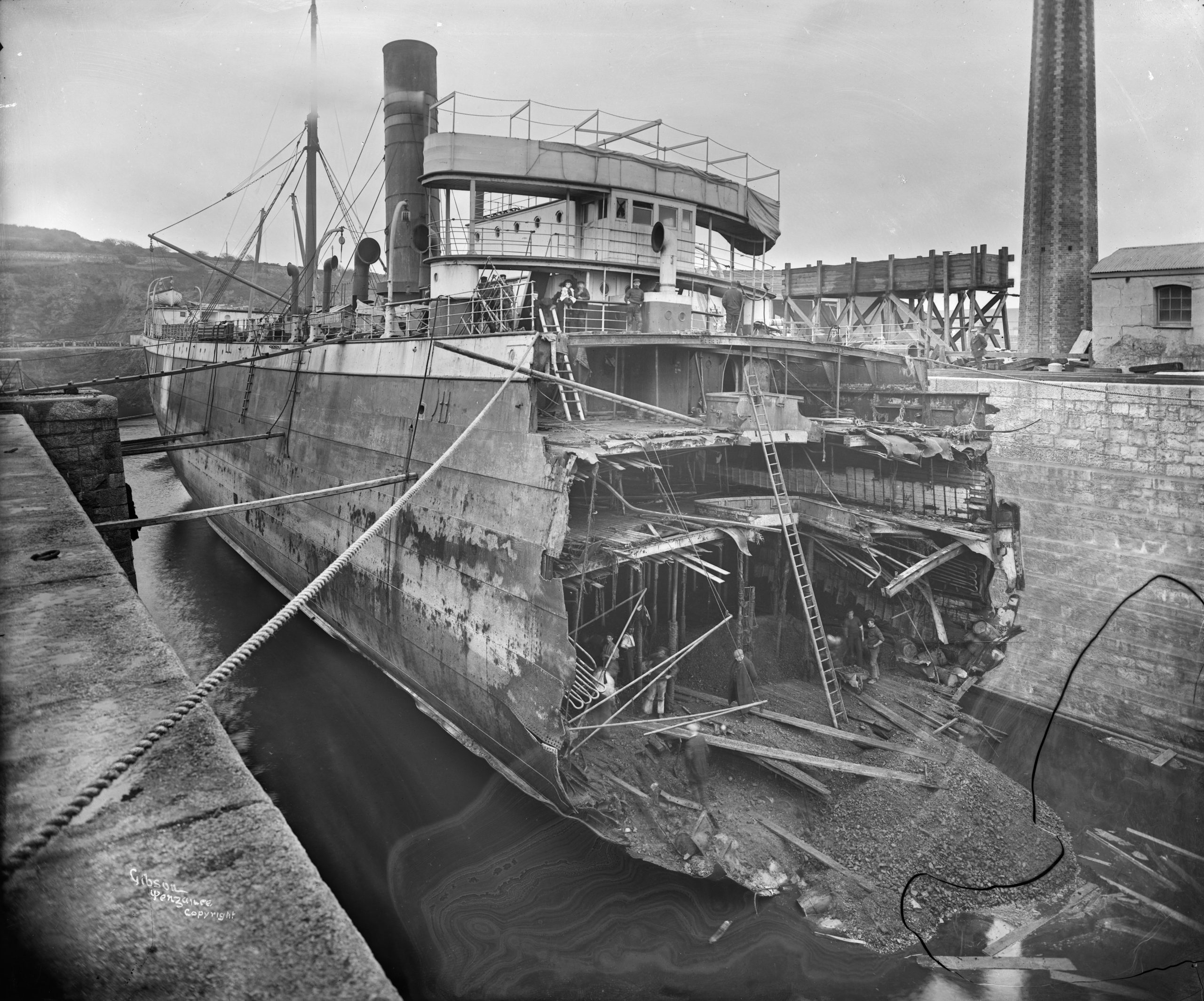
A breakwater in the sea
In the late-nineteenth century, the work of making a breakwater was hard, and it also required work beneath the sea. The nature of the work changed according to whether the monsoon was in force or not. During the monsoon, stones and blocks and quantities of sand could be washed away unexpectedly. Additionally, the nature of the waves changed dramatically. The importance of keeping an eye on the sea in making plans for breakwater-making was especially evident in how records were kept on this seafront on wave heights, wave periods and winds. It was supposed at first that nine feet was the greatest height of waves at Colombo, but subsequent measurements determined that where the breakwater was being built waves rose to twelve feet and fifteen feet.Image: KHK global dis:connect collection
Line of control
The breakwater is a line, a line of attempted control between sea and land. But it also served this purpose for the control of disease.[5] In the 1890s a large number of vessels were put under quarantine as fears of plague spread. By 1905 disinfection was undertaken ‘at the root of the breakwater’ with ‘an Equifex disinfector [a boiler and three disinfecting chambers]’[6] which was erected at that point alongside an immigration depot. The Bombay steamer was a particular target: all Bombay water was emptied off the ship rather carefully. Each individual on the Bombay steamer was allegedly inspected; their temperature taken, and ‘the state of the glands of his (sic.) neck, groins and armpits’ were examined; while ‘[f]emales are examined by a female examiner.’[7]Beach reorganisation
The growing harbour of Colombo would not have expanded the way it did without the new breakwaters. For this was not a site with a significant natural harbour; the breakwaters made it possible for Colombo to become a site of trans-shipment at the centre of the Indian Ocean. Meanwhile, their construction and the resulting expansion of the city saw urban reorganisation. For instance, the harbour was emptied of ‘native vessels’[8], used by fishermen and a separate fishery harbour arose to the north of the main port in 1902. But once again, like in the assault of the waves on those who were building the breakwaters, this programme of managing the sea-face did not work. Fishing communities were incensed by their relocation. In one petition of 1906 with 11 signatures, for instance, they wrote against how their boats were forbidden to fish in the harbour area where they had traditionally done so. ‘True it is the Government have provided for us outside the Colombo Harbour, a place called ‘Fisher’s Harbour’... during the SW Monsoon the entrance of the harbour is not safe and the room for the accommodation of our fishing boats … is quite insufficient’[9]. Various catamarans, fishing boats, that sought to continue operating in the harbour were seized by the harbour police. Meanwhile, the beach that was allocated to fishing communities was divided up so that different groups, demarcated by place of worship, had access to different stretches of the shore.Resistance
In late 1894, when the railway line was being laid along this stretch of shore, there were ‘disturbances’ at St. John’s Beach, and the accusation that some men had incited ‘a riot’ and turned on government officials.[10] This resistance was not only human; it was natural too. A fishermen’s petition from 1901– from a group who had beached their boats close to Mutwal and the mouth of the Kelani River since ‘immemorial’ times – complained of all the functions occurring on their beach. The result was that:[The] flow of water in the river is greatly obstructed by the large number of timber lying in the bed of the river and fever is spreading amongst the poor families of the fishermen who use the river for bathing purposes, the water being stagnant, the mud at the bottom has become putrid and the smell very offensive. [11]By 1912, the problems of space had affected fishing communities to the extent that one Sinhalese group, taken to be the majority ethnic community in the island today, asked that ‘Tamil’ fishermen be ousted from Colombo, on the basis that Tamils ‘are not residents of Ceylon’ and also since these fishermen were using types of nets prohibited by the state.[12] Modes of attempted management, to allow the port to connect, allowed inter-community relations in turn to deteriorate to ethnic tussles.
The stage of dis:connection
To move from the early twentieth century to the present and the sustained protests on this stretch of beach, there are various geopolitical reasons for their emergence. Grand schemes by the Chinese and Indians and others, including the Japanese, dictate the present and future of Colombo as well as the whole island. The pandemic and the loss of tourist and migrant labour incomes, for instance in the Middle East, have played a role too. In addition to this, it is also about the hold of an older generation of corrupt male politicians, who adopted supposedly populist tax cuts and new fertiliser policy for agriculture. If these reasons can be taken to indicate de-globalisation, strikingly, the protests of our moment have been led by the young and by those who did not grow up in the midst of the island’s civil war, between the Sinhala majority and the Tamil minority. The protests have crossed ethnic boundaries and seen the rise of new forms of solidarity. Muslims, one of the most discriminated communities, have broken fast in the midst of the protests. I want to end simply by stressing that these protests have also occurred on a stage facing the ocean. This is a lawn that repeated governments have struggled to keep green and struggled to convert into an iconic landscape of nationalism. It is fitting also that the protesters who stormed the president’s residence were seen swimming in a pool of water. It was this recording, together with others of the protests movement on the stretch of shoreline, that went viral when the news first broke.[13] Going into the water was a way of bringing a political movement to its sweet result: Colombo is a specific ecology, which has faced connection and disconnection, over centuries and not only at the hands of the British, but also the Portuguese and the Dutch and now various other superpowers. It is in the gap between connection and disconnection that Colombo has given rise to new political forms. The breakwater or indeed the lawn or harbour, have been effective places from which to rethink the political in a global South city. Meanwhile the performative possibilities of sites facing water carry on apace. [1] This blog returns to an earlier article while bringing in lots of new dimensions: Sujit Sivasundaram, ‘Towards a Critical History of Connection: The Port of Colombo, the Geographical “Circuit,” and the Visual Politics of New Imperialism, ca. 1880–1914’, Comparative Studies in Society and History 59, no. 2 (2017): 346–84. [2] For an excellent introduction to the story see: Kanchana Ruwanpura, Benjamin Brown, and Loritta Chan, ‘(Dis) Connecting Colombo: Situating the Megapolis in Postwar Sri Lanka’, The Professional Geographer 72, no. 1 (2020): 165–79. [3] For some recent commentary on the protests and their causes, see for instance: J. Uyangoda, ‘The #GotaGoHome Protest Movement: Significance, Potential, and Challenges’, Social Scientists’ Association, 2022, http://ssalanka.org/gotagohome-protest-movement-significance-potential-challenges-jayadeva-uyangoda/; and: Shamara Wettimuny, ‘Protests in Sri Lanka: A Historical Perspective’, Medium, 10 April 2022, https://shamara-wettimuny.medium.com/protests-in-sri-lanka-a-historical-perspective-289e58908c5a. [4] See: Sujit Sivasundaram, Islanded: Britain, Sri Lanka, and the Bounds of an Indian Ocean Colony (Chicago: University of Chicago Press, 2013); See also: Zoltán Biedermann, ‘(Dis)Connected History and the Multiple Narratives of Global Early Modernity’, Modern Philology 119, no. 1 (2021): 13–32, https://doi.org/10.1086/714972. [5] For references to the primary material in this paragraph and that following, please see: Sivasundaram, ‘Towards a Critical History of Connection: The Port of Colombo, the Geographical “Circuit,” and the Visual Politics of New Imperialism, ca. 1880–1914’. [6] Sivasundaram, 'Towards a Critical History'. [7] Sivasundaram, 'Towards a Critical History'. [8] Sivasundaram, 'Towards a Critical History'. [9] ‘Petition to the Hon’ble Government Agent of the Western Province’, 25 October 1906, Lot 33/3964, Sri Lanka National Archives. [10] ‘Documents’, n.d., Lot 33/3961, Sri Lanka National Archives Colombo. [11] ‘Petition’, 3 December 1901, Lot 33/3481, Sri Lanka National Archives. [12] ‘Petition to the Master Attendant from Signatories Who Sign in Sinhala’, 27 March 1912, Lot 33/3976, Sri Lanka National Archives. [13] ‘Sri Lanka Crisis: Protesters Swim in President’s Pool’, BBC, 9 July 2022, https://www.bbc.com/news/av/world-asia-62105698.Bibliography
Biedermann, Zoltán. ‘(Dis)Connected History and the Multiple Narratives of Global Early Modernity’. Modern Philology 119, no. 1 (2021): 13–32. https://doi.org/10.1086/714972. ‘Documents’, n.d. Lot 33/3961. Sri Lanka National Archives Colombo. ‘Petition’, 3 December 1901. Lot 33/3481. Sri Lanka National Archives. ‘Petition to the Hon’ble Government Agent of the Western Province’, 25 October 1906. Lot 33/3964. Sri Lanka National Archives. ‘Petition to the Master Attendant from Signatories Who Sign in Sinhala’, 27 March 1912. Lot 33/3976. Sri Lanka National Archives. Ruwanpura, Kanchana, Benjamin Brown, and Loritta Chan. ‘(Dis) Connecting Colombo: Situating the Megapolis in Postwar Sri Lanka’. The Professional Geographer 72, no. 1 (2020): 165–79. Sivasundaram, Sujit. Islanded: Britain, Sri Lanka, and the Bounds of an Indian Ocean Colony. Chicago: University of Chicago Press, 2013. ———. ‘Towards a Critical History of Connection: The Port of Colombo, the Geographical “Circuit,” and the Visual Politics of New Imperialism, ca. 1880–1914’. Comparative Studies in Society and History 59, no. 2 (2017): 346–84. BBC. ‘Sri Lanka Crisis: Protesters Swim in President’s Pool’, 9 July 2022. https://www.bbc.com/news/av/world-asia-62105698. Uyangoda, J. ‘The #GotaGoHome Protest Movement: Significance, Potential, and Challenges’. Social Scientists’ Association, 2022. http://ssalanka.org/gotagohome-protest-movement-significance-potential-challenges-jayadeva-uyangoda/. Wettimuny, Shamara. ‘Protests in Sri Lanka: A Historical Perspective’. Medium, 10 April 2022. https://shamara-wettimuny.medium.com/protests-in-sri-lanka-a-historical-perspective-289e58908c5a.citation information:
Sujit Sivasundaram, ‘Breaking Water: The Dilemmas of Dis:Connection in a Global-South City’, 2 November 2022, https://www.globaldisconnect.org/11/02/breaking-water-the-dilemmas-of-disconnection-in-the-global-south-city/?lang=en.
Continue Reading
2 November 2022